Northern Illinois
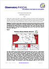
The Northern Illinois region comprises the service area of Northern Illinois University and feeder community colleges plus the Chicago metropolitan region, a global economic hub. Geographically, the region consists of 6,765 square miles of land (17,625 KM) and includes the area within the State of Illinois that lies north of Interstate 80. The region is bounded on the east by Lake Michigan, on the west by the Mississippi River, and on the north by the State of Wisconsin. (See Figure 1).
Figure 1

The state of Illinois has the largest number of governmental units in the U.S. In 2002, Illinois, with 6,903 units, surpassed Pennsylvania by 1600 units, the state with the next largest number. These units consist of counties, municipalities, townships, school districts, and a host of special districts (e.g., fire protection, health, hospitals, libraries, drainage and flood control, sewerage, water supply, and others). While decentralized governmental systems offer more opportunities for residents to participate in decision-making and are more transparent, they can become fragmented, unable to attract quality management, and, for purposes of the PURE initiative, make collaborative planning challenging. The multiplicity of boundaries associated with governance, planning, and taxation throughout Illinois has resulted in uncoordinated definitions of regions. One advantage of using a large geographic region for PURE is that the misalignment at the local level among education, workforce development, and economic development service delivery regions tends to lessen at a larger scale.
 Printer-friendly version
- 109 reads

